Death Valley CA is an interesting place. A place with a dry, forbidding and hostile environment but when one ventures off into one of the myriad of canyons one experiences the tremendous and beautiful power of flash floods. Slick canyon walls that have been carved out over the years are just jaw dropping in beauty. And speaking of beauty, the wild flowers were in abundance during this trip.
This hike is on the Iron Mountain, Appalachian and Virginia Creeper trails. The elevation changes are not too tough but there is a bunch of them. There were not many views but we reached the high point of Virginia.
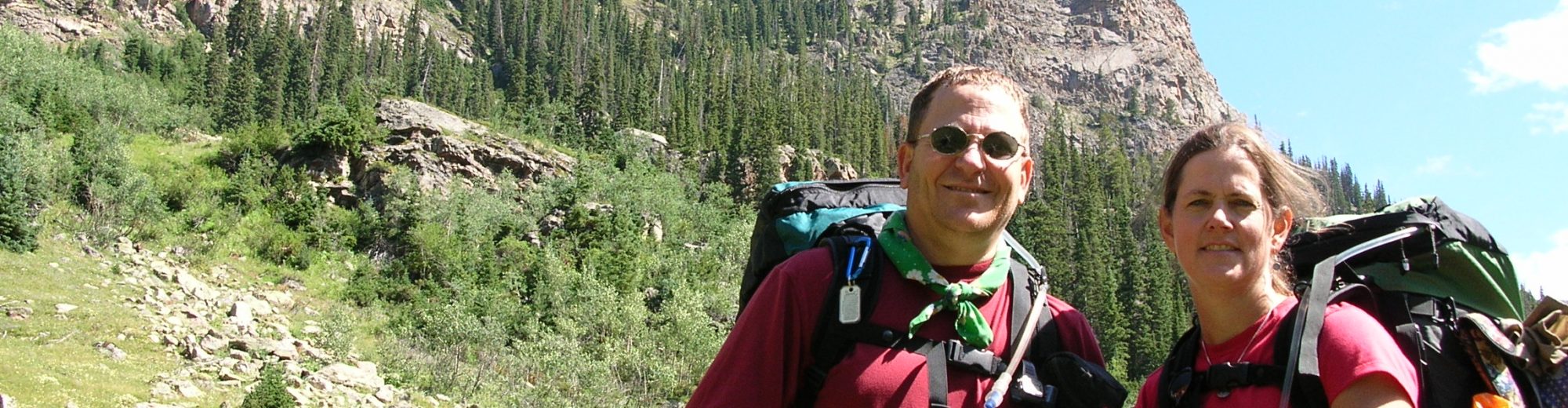
Start of the hike at the Tonahutu/North Inlet trailheadSide trip to Haynach Lake.
August 1, 2005: Started the backpack at Tonahutu / North Inlet trailhead at 10:00 am and arrived at Sunrise Camp at 2:45. We had a relaxing lunch alongside the Tonahutu River. There were two big events during the day, both occurring at about the same time. First, directly across from the Big Meadows camp in the big meadows we spotted two bull moose grazing. And then, while watching the moose, we were treated to about 2 minutes of pea sized hail.
August 2, 2005: Got a late start. We had to spend a part of the morning drying out equipment before packing up. It rained all night long. Our first stop during the day was at Granite Falls. Since today was not a big miles day we took a 4 mile round trip day hike to Haynach Lake.
August 3, 2005: We decided to hit the trail early today (7:00 am) so we could beat the afternoon thunderstorms as we were crossing the Continential Divide. It was overcast most of the day and we hit the high point of Ptarmigan Point at noon and immediately headed down. The initial mile of downhill was marked by double cairns about 6 foot tall. After that we hit significant switchbacks as w descended to our camp for the night – Camp July. After setting up camp the sky was threatening rain so Lori and Carl went in search of a the privy. Instead they were treated to 3 bull elk grazing in a field across Hallett Creek about 50 yards away. These powerful beasts with magnificent racks kept us mesmerized for 20 minutes. Then after finding the privy Carl and Lori were treated to 4 mule deer -a buck, doe, and 2 fawns – all that seemed very tame. Shortly afterward the sky darkened and rain drops started to falling. All of us retired to our respective tents to wait out the storm. It was a powerful storm with rain, wind, thunder, and lightening. After about an hour we heard voices outside our tents. A father and two sons were standing under our tarp, soaking wet, shivering and without any gear – asking for our help. They got caught in the lightening storm on top and had been trying to get below treeline when lightening began hitting within 200 yards of their location. They hunkered down hoping to wait out the storm. When it didn’t abate they dropped packs and ran downhill to our camp. We fired up our stove to provide hot Gatorade and tea. Their cotton clothing was soaked so we shared our extra gear to help warm them up. When the rain let up, Ann, Carl and Lenny (the father) walked up the trail about a mile to retrieve their backpacks so they could set up their tent next to ours. More elk were spotted on the trip. It rained all night long.
Double cairns marking the trailElk with a full rack.Campsite during an afternoon thunderstorm.
August 4, 2005: We awoke to overcast skies, rain and sinking spirits. The father and two sons with us were still wet and cold so Carl offered to give his polar fleece to one of the boys to use if they would mail it back when they got home. It never hurts to provide a bit of trial magic when you can. A short, quick consultation resulted in a decision to hike out a day early since most our gear was getting damp and, hey, this IS a vacation. We set out before Lenny and his sons and after another set of switchbacks we hike the gentle downhill trail to Tonahutu/North Inlet trailhead and our rental car. The rain stopped as we started hiking out causing us to question our decision until we got to the car, opened the trunk to load gear and rain started pouring! Decision confirmed!
On the trail.Moose in a field.
Post Script: Carl never received the polar fleece in the mail. However, helping someone in need on the trail is never wrong!
A backpacking trip report about a counterclockwise backpacking trip around Mt Hood Oregon. On this trip were Ed Tucker, John Gundry, and me (Carl Fisher).
September 8, 2002 Miles: 8.8
We stayed in a motel on the 7th in Portland OR and got up at 5:00am and on the road to Mt. Hood at 6:30am. Timberline Lodge, our starting point, was achieved at 7:30am and we were able to hit the trail at 8:15am. The first part of the trail was downhill so we made really good time before crossing two ridges and two major streams with no bridges.
Ed had to put at least one foot in each stream and was the start of his trail name “Splash”! The day ended at a site near the intersection of the Timberline Trail and Elk Meadow at an elevation of 5720 feet. The temperature for most of the day was in the 50’s and very comfortable.
Camp was set up and dinner eaten by 6:00pm. I was tired from both the physical exercise and lack of sleep the night before. We were all in the tent and our bags by 8:00pm and asleep by 8:30. I slept through the night until 5:00am when my feet got cold.
Campsite on the first nightMt Hood shrouded in the clouds
September 9, 2002 Miles: 9.8 Cumulative Miles: 18.6
Since we are all early risers, we were up at 6:00am and on the trail at 7:30am. All uphill until 9:00am for 1000 feet and there is 400 feet more to go. Fortunately, this will be the high point for the day and the trip. The soil / trail has been very sandy with lots of rocks. Real fun on the footing! We made it to the high point at 10:00am and asked someone to take our picture with the cairn marking the spot with Mt Hood in the background.
High point of the Timberline Trail with Mt Hood in the background
As would be expected we kept on hiking, mainly downhill, until we reached Cloud Cap, our intended destination for the evening. Since it was only 11:45am we agreed to keep going and made it all the way to Elk Cove. We camped right alongside a stream (a big no-no) but very handy for getting water and cleaning up. Our camp was only about 5 feet off the trail (another by no-no). This was my first back to back big mileage days!
September 10, 2002 Miles: 11.8 Cumulative Miles: 30.4
The temperature is in the low 40’s when we hit the trail at 8:00am but quickly rose to a comfortable 60’s. There were excellent views all day long of Mt Adams, Mt Saint Helens, and Mt Rainier. A long break seemed the right thing to do at Carin Basin where there were numerous campsites and a stone building. This would have been an excellent place to stay but there was still a lot of day left.
We skipped Eden Park to cut 0.6 miles off the entire trip. Prior to getting to Bald Mountain we decided to cut about a mile off the trip by going cross country, up a watershed and then down the other side, a hike of about 100 yards. This put us on the Pacific Crest Trail. Two miles down the trail we came up to Muddy Fork River which was washed out by a mud slide the previous year.
The power of the mud slide was incredible as evidenced by the 100’s of old, mature trees strewn about like matchsticks. Needless to say – getting across this ¼ mile stretch was challenging but fun! We had to hop from boulder to boulder which had been placed by the mud slide like so many grains of sand.
The night was spent on a sandbar of the Sandy River. Before getting to the Sandy River we spent about an hour at Ramona Falls – a 50 foot waterfall nestled right off the trail. The area was cool and refreshing.
Muddy Fork River washed out by a mud slide.Mt Hood shrouded in the cloudsCrossing a snow field
September 11, 2002 Miles: 9.2 Cumulative Miles: 39.6
Today was billed as a “butt kicker” by John and it lived up to the billing. Our plan was to make the first major ascent (2100 feet) and about 3 miles and to assess the time and how we felt to determine if we were going to continue. Amazed, we reached this point at 10:00am feeling strong so we made the decision to push on to the car. From this point on we gained another 1000 feet, mainly in the sun with temperatures approaching 80 degrees. We got to the car at 2:30pm.
Trail thru the rocksPacking up to hit the trail.On the way out
Today was the day for flying and getting all of the parties together. Lori and Carl flew from Green Bay WI to Reno NV. Kay drove to Green Bay from Michigan to leave her kids with Karen Burke (her sister), then drove to Milwaukee and finally flew to Reno NV. John flew from Detroit MI to Reno NV.
John missed his original flight and was able to get a direct flight that got him in earlier than expected. We rented a car, however, because Carl indicated we were arriving at 10:00pm instead of 10:00am we were not able to get a full sized car and had to settle for a midsized car. It worked out OK but Carl did take a fair amount of ribbing.
We had lunch in Reno at a “On the Border” restaurant before arriving to Tuolumne Meadows at 4:45pm where we obtained our trail pass. Finding our backpacking campsite was a breeze and we set up tents. Carl went to the visitors center to meet Tim and Susan who were driving in from Phoenix, AZ. We were supposed to meet at 6:00pm and by 6:30pm Carl left messages and came back to the others. Carl drove back to the visitors center (no luck), found the trailhead to speed things in the morning, and then stopped at the country store. It was now 7:30pm. As Carl was standing in line to buy a “Sunrise High Sierra Camp” patch he saw Tim and Susan driving by slowly looking for us. Just plain lucky we found each other (this was before cell phones).
Tim and Susan had driven into the Valley at 5:00pm but didn’t realize that it was another 1-1.5 hours to Tuolumne Meadows. They had been driving back and forth searching for us. Since everyone was hungry we headed for the Tuolumne Lodge where we were able to get the last table of the evening. The food was decent for being in the middle of nowhere.
Dinner at Tuolumne Lodge before starting the hike
June 23, 2002 (First day of hiking)
8:00am – bright, sunny morning with a temperature of 44 degrees at 6:00am. Almost everyone has new great and is experimenting on how to pack. We are close to leaving. Lori called Megan and she was worried about us because Tim and Susan had called her last night. Today is going to be the hardest day with 1500 feet of up and 1500 down and crossing a very wet meadow.
Noon – Lunch at the intersection of our trail and the trail to Cathedral Lakes. This morning was passed Fairview Dome and Cathedral Peak – views were not so stunning. A lot of uphill. Bright, sunny and in the mid 70’s. Everyone on the trail has been friendly and talkative.
Night – We camped right on the edge of Sunrise Mountain.
Tim telling silly stories
June 24, 2002 (Second day of hiking)
8:00am – Our walk yesterday PM through Tuolumne Meadows was very brisk! The mosquitoes were terrible. All in all we did 9 miles – really more than we should have – we were all really tired. There was a little disagreement at the end of the day about where to stay, therefore, John and Kay stayed about a ¼ miles further down the trail because Susan and Lori did not want to walk any further.
Supper was a quick affair because of the mosquitoes and we were all in bed at 8:30pm. Carl had a restless night because he was somewhat dehydrated. Morning was uneventful with the normal oatmeal, packing up and swatting at mosquitoes. The views are nice but Carl was anxious to get into the Valley.
8:00pm – We made it to our goal for the day – the last junction before the Half Dome. We walked at a very “restful” pace and made it to our destination around 3:30pm. We spent an hour looking for a better site and, finally, found a good one to basecamp from. We talked to some folks that had just come down from the Half Dome. They indicated it took 2 hours to go up and 1.5 hours to come down. They were in their 50’s – the woman loved it and the man hated it. An interesting item has been the scat we have been seeing on the trail – mainly undigested grass about 3 inches long and 1 inch in diameter.
June 25, 2002 (Day 3 of hiking)
8:00am – We had a bear walk through the camp last night. At midnight Lori started out of the tent to take a nature break – immediately she came flying back into the tent, zipping the door shut saying, “There’s a bear!”. “Oh, good thing you zipped the tent.” replied a sleepy but wide awake Carl. The bear had just finished checking out our food barrels and then sauntered through camp. The bear came to within 6 feet of the tent as he lumbered over to sniff our backpacks before heading for John and Kay’s tent.
No major problems except for Kay not sleeping all night. We were slower getting going than we wanted to be on our hike to Half Dome. We didn’t get started until 9:00am. Kay and Susan decided not to do the major assent to the top. It took the rest of us a total of 2 to 2.5 hours to get to the top. The initial ⅔ of the trail was primarily wide trail with lots of switchbacks. The final third had two distinctly different sections. The first section was a trail made of steps that had been carved and set into the mountain. There were no hand rails and Tim commented, “I don’t think these steps meet building code for rise and run!”. Lori had to overcome her fear and in some sections looked like a crab scrambling uphill. The second section is the one that gets all of the write up and it was by far the most challenging. This section consisted of 2 cables connected to 1 ½ inch pipes that were drilled into the stone and set about 3 feet high and 4 feet apart.
Climbing Half DomeClimbing Half DomeFinding gloves for the assent from a pile left at the bottom of half dome.
When Carl got to the top his arms were shaking and he thought to himself, “I don’t know if I’m going to make it down!” The views are gorgeous and we all spent an hour on the top. Much to everyone’s relief, coming down was much easier. More like a controlled fall, using ones hands to clamp on the cable to slow or stop the descent.
Carl standing on the Diving Board atop Half Dome.
June 26, 2002
Last day and it is all downhill hiking along the Mist and Vernal Falls.